Bora Bora is an island and commune of French Polynesia in the Leeward group of the Society Islands, about 265 km northwest of Tahiti in the central South Pacific. The main island, ringed by a barrier reef and motus (islets), rises to Mount Otemanu (727 m), while the commune’s population was 10,758 in 2022. The name—traditionally Porapora—means “First Born.” Tourism is the leading economic activity, with additional production of copra, vanilla, and mother‑of‑pearl. Bora-Bora | Facts, History, & Points of Interest – Encyclopaedia Britannica;
Décret authentifiant les résultats du recensement 2022 – tableau II (Bora-Bora 10 758);
INSEE Première 1990 – évolutions 2017–2022, Bora Bora 10 760.
Geography and geology
Bora Bora is the deeply eroded remnant of a hotspot shield volcano whose subaerial lavas date to roughly 3.45–3.10 million years ago; a 4.4 km summit caldera is recognizable, and subsidence has produced the broad lagoon now enclosed by a barrier reef. Basaltic lavas predominate, with rare hawaiites and post‑shield dikes. Comptes Rendus Géoscience – “Geology, geochemistry and geochronology of Bora Bora island” (Blais et al., 2000) via ResearchGate;
Society Islands geology overview.
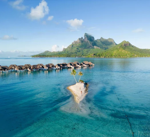
The highest point is Mount Otemanu (727 m) alongside Mount Pahia (658 m). The lagoon communicates with the open ocean through Teavanui Pass on the west side, the island’s only navigable pass. Bora-Bora – Britannica;
Mount Otemanu;
Noonsite cruising guide (Society Islands – Bora Bora);
Sea‑Seek pilotage note, “C’est la seule passe donnant accès au lagon”.
Administration and settlements
Bora Bora is a French commune comprising the main island with its surrounding motus and the uninhabited atoll of Tupai, c. 20 km to the north. It has three associated communes: Nunue, Faanui (to which Tupai is attached administratively), and Anau; the chef‑lieu and principal settlement is Vaitape. Syndicat pour la Promotion des Communes de Polynésie française (SPCPF);
Commune’s official site;
Bora‑Bora (commune) – 2022 population and administrative notes.
Early settlement and European contact
Traditional accounts hold that the island’s name Porapora (“First Born”) reflects its primordial creation in local cosmology. The first recorded European sighting was by Dutch admiral Jacob Roggeveen (1722), with later visits by James Cook in 1769 and 1777; Bora Bora was annexed by France in the late 19th century. Bora-Bora – Encyclopaedia Britannica.
World War II and strategic role
During World War II, the United States established a major supply base on Bora Bora (code name “Operation Bobcat”), building fuel depots, coastal defenses, a seaplane facility, and the airfield that later became the island’s airport. The pioneering Naval Construction Detachment dubbed themselves the “Bobcats.” U.S. Navy Seabee Museum/History of Seabees – WWII;
U.S. Navy Seabee Magazine history note on “Bobcats”;
Britannica.
Economy
Tourism dominates the economy, centered on luxury resorts—many with overwater bungalows built on motus around the lagoon—while copra, vanilla, and mother‑of‑pearl are also produced. Britannica. Overwater bungalows, first created in French Polynesia in the late 1960s and later popularized at destinations including Bora Bora, are now emblematic of the islands’ resort infrastructure.
The Story Behind the World’s First Overwater Bungalows – Condé Nast Traveler;
Washington Post (2017) – 50 years of overwater bungalows.
Language, currency, and status
French and Tahitian are the principal languages; legal tender is the CFP franc (ISO code XPF), pegged to the euro, and issued by the Institut d’émission d’outre‑mer. French Polynesia has substantial internal autonomy as a French overseas collectivity. CIA World Factbook – French Polynesia (Languages);
CFP franc;
French Polynesia status overview.
Transport
Bora Bora Airport (IATA: BOB; ICAO: NTTB) sits on Motu Mute, built initially by U.S. forces and placed in civilian service in 1958. Because it is on an islet within the lagoon, passengers transfer by boat to Vaitape or directly to motu‑based resorts. Aéroport de Bora‑Bora – history and specifications;
Air Tahiti – airport and ferry transfer information;
Tahiti Heritage – Motu Mute airfield history.
Climate and environment
The climate is tropical and equable year‑round, with mean monthly temperatures around 25–27 °C and a wetter season roughly November–April. Observations from the Vaitape/Motu‑Mute station show pronounced seasonal rainfall variation. Lagoon use is regulated to protect cables, outfalls, and marine habitats; Bora Bora has designated no‑anchor zones and managed moorings. Climate‑Data.org – Vaitape (Bora Bora);
DPAM (Polynésie française) – Règlementation des zones de navigation, mouillage et natation; Arrêté CM n°2956 du 31/12/2018 (Bora Bora);
DPAM anchor/mooring framework.
Notable places and features
Key localities include Vaitape, the administrative and commercial hub on the west coast; Matira Beach at the southern tip; WWII coastal gun emplacements; and the motus of Toopua/Toopua Iti that shelter the western lagoon. Tupai, a heart‑shaped atoll administratively attached to Bora Bora, is uninhabited aside from seasonal activity. Britannica;
Communal site;
Tahiti Tourisme – Tupai.