The Canary Islands are an Atlantic archipelago and Spanish autonomous community comprising eight inhabited islands and several islets, located about 100 km off the northwest African coast in the Atlantic Ocean. The community has dual capitals—Las Palmas de Gran Canaria and Santa Cruz de Tenerife—under a system of shared capital status established by statute. As of the third quarter of 2025, the resident population was 2,268,035, according to Spain’s National Statistics Institute (INE). BOE (LO 1/2018);
Europa Press (INE data).
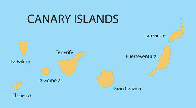
Geography and main islands
- –The archipelago forms part of Macaronesia along with Azores and Madeira, and consists of the larger islands of Tenerife, Gran Canaria, Fuerteventura, Lanzarote, La Palma, La Gomera and El Hierro, plus the smaller inhabited island of La Graciosa and several islets (Alegranza, Montaña Clara, Lobos, Roque del Este, Roque del Oeste). La Graciosa was officially recognized in 2018 as the eighth inhabited Canary Island.
European Commission – ORs;
El País.
- –The territory is organized into the provinces of Las Palmas and Santa Cruz de Tenerife, a division created by Royal Decree in 1927.
BOE – Gaceta de Madrid archive (23 Sep 1927).
- –The highest point is Teide on Tenerife (3,715 m), within Teide National Park; Spain’s environment ministry lists 3,715 m as the official elevation.
MITECO – Teide National Park.
Geology and volcanism
- –The islands are of volcanic origin, formed above a long-lived mantle hotspot that built successive islands from older in the east to younger in the west. Tenerife’s central complex (Teide–Pico Viejo) rises within the Las Cañadas depression, a large volcanic structure.
NASA Earth Observatory;
Springer/ULPGC chapter.
- –The archipelago remains volcanically active. On La Palma, the 2021 Tajogaite (Cumbre Vieja) eruption lasted from 19 September to 13 December 2021 (85 days), producing extensive lava flows and leading to evacuations. The official chronology and end-of-eruption declaration were issued by PEVOLCA and Spain’s National Geographic Institute.
IGN (erupción La Palma 2021);
IGME-CSIC.
Climate
- –The climate is predominantly subtropical, shaped by the Azores High and persistent northeast trade winds that create marked windward-leeward contrasts and frequent temperature inversions (“sea of clouds”) in the higher relief islands. AEMET’s climate atlas and technical notes describe these patterns and their seasonal variability.
AEMET – Atlas climático de Canarias, Madeira y Azores;
AEMET Blog.
- –Timekeeping follows Western European Time (WET, UTC±0) in winter and Western European Summer Time (WEST, UTC+1) in summer.
timeanddate.com;
Wikipedia – Time in Spain.
Biodiversity and natural heritage
- –The islands host high endemism across bioclimatic zones, including laurel cloud forests (laurisilva) and the fire-adapted Canary Island pine (Pinus canariensis). The laurisilva is conserved notably in Garajonay National Park on La Gomera.
UNESCO WHC – Garajonay;
- –Four UNESCO World Heritage Sites are inscribed in the archipelago: Teide National Park (Tenerife), the historic center of San Cristóbal de La Laguna (Tenerife), Garajonay National Park (La Gomera), and Risco Caído and the Sacred Mountains of Gran Canaria Cultural Landscape.
UNESCO (Risco Caído).
- –Several islands are also UNESCO Biosphere Reserves (entirely or in part), including El Hierro (expanded marine area in 2022), La Palma (entire island since 2002), La Gomera (2012), Fuerteventura (2009), and others.
History
- –The indigenous Guanches and related island groups inhabited the archipelago prior to Castilian conquest; they were largely of Berber origin. Conquest proceeded between 1402 and 1496 under the Crown of Castile, with Jean de Béthencourt’s early campaigns in the eastern islands and the later royal campaigns culminating in Tenerife’s subjugation.
Britannica – Guanche and Canario;
- –The autonomous community was constituted by statute in 1982 and reformed in 2018. The statute fixes shared capital status between Las Palmas de Gran Canaria and Santa Cruz de Tenerife, with provisions on alternating executive seats and institutional distribution.
BOE – LO 10/1982 (historical);
BOC – capitalidad compartida, 1996/1997.
Government, EU status and fiscal regime
- –Within Spain, the Canary Islands comprise two provinces and seven island cabildos (insular councils). They are also an outermost region of the European Union under Article 349 TFEU, enabling adapted EU policies and specific measures in areas such as taxation, customs, and state aid.
European Parliament – Outermost Regions;
EUR-Lex – ORs.
- –The region maintains a special economic and fiscal framework (REF), including the Canary Islands Special Zone (ZEC) with a 4% corporate tax rate on eligible activities and AIEM provisions for local industry.
Spanish Tax Agency – ZEC (4% rate);
European Commission – AIEM decision.
Economy and society
- –Tourism is the leading economic sector. Official data indicate 17.77 million tourist arrivals in 2024 (by air), with strong foreign demand led by the UK and Germany; Spain’s national reporting places international tourist spending in the archipelago at about €22.9 billion in 2024.
Ministry of Industry and Tourism (Spain), 2024 results.
- –Demographically, growth in recent years has been driven largely by foreign-born residents, while natural increase remains negative. The population reached 2,268,035 in Q3 2025 (INE).
Europa Press (INE data).
Culture and science
- –The islands host internationally significant observatories and research sites, including Teide Observatory (Izaña) and volcanic monitoring networks, as well as protected cultural landscapes such as Risco Caído that preserve pre-Hispanic troglodytic sites and ritual spaces.
Protected areas and UNESCO designations
- –World Heritage Sites: Teide National Park; San Cristóbal de La Laguna; Garajonay National Park; Risco Caído and the Sacred Mountains of Gran Canaria Cultural Landscape.
- –Biosphere Reserves (selection): El Hierro (expanded marine component, 2022), La Palma (entire island), La Gomera, Fuerteventura, Gran Canaria (partial).
Notes on elevation and measurement
- –Teide’s commonly cited 3,718 m (UNESCO profile) reflects historical figures; Spain’s official protected-area documentation states 3,715 m. This entry follows the Spanish government’s figure for consistency with national geographic data.