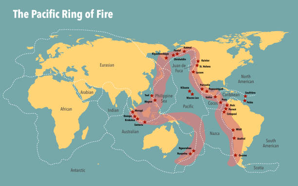
The Pacific Ring of Fire is a circum-Pacific belt of active volcanoes, deep ocean trenches, and frequent earthquakes that outlines the Pacific Basin in a horseshoe roughly 40,000 kilometers (25,000 miles) long, as described by NOAA Ocean Exploration and
National Geographic. The belt traces the margins of the Pacific Plate and neighboring plates where convergence, divergence, and transform motion concentrate geologic hazards, according to the U.S. Geological Survey (
USGS).
Definition and extent
The Ring of Fire refers to a chain of volcanic arcs and oceanic trenches fringing the Pacific, rather than a continuous structure, and it is better understood as a zone of interacting plate boundaries than as a single geologic entity, as noted by NOAA Ocean Exploration and by reference overviews from
National Geographic. The belt includes major arcs such as the Andes, the Cascades of western North America, the Aleutian Islands, the Japanese and Kuril arcs, the Philippines, and parts of Indonesia and New Zealand, summarised by
Britannica and
USGS.
Plate-tectonic setting
Most activity along the belt is driven by subduction zone processes in which dense oceanic lithosphere slides beneath an overriding plate, generating arc volcanism, deep trenches, and earthquake sequences that can extend to ~700 km depth in Wadati–Benioff zones, as outlined by USGS and explained in accessible terms by
Britannica. The Ring of Fire follows the boundaries of multiple plates—including the Pacific Plate, North American, Cocos, Nazca, Philippine Sea, Juan de Fuca, Australian, and smaller microplates—whose motions create subduction interfaces and associated hazards, as summarized by
National Geographic and mapped by
USGS. While much of the belt involves subduction, some segments are dominated by transform motion that does not typically produce arc volcanism, for example the San Andreas and Queen Charlotte faults along coastal North America, as outlined by the U.S. National Park Service’s transform-boundary primer (
NPS).
Volcanism
Approximately three-quarters of Earth’s active volcanoes lie along the Ring of Fire, with more than 450 volcanoes commonly associated with this belt, according to National Geographic and
NOAA Ocean Exploration. Global context from the Smithsonian’s Global Volcanism Program indicates about 1,300 Holocene (past ~12,000 years) volcanoes worldwide, many concentrated in circum-Pacific arcs (
GVP). The submarine component is substantial, and dedicated surveys in the Mariana, Lau, and Kermadec arcs have documented active undersea eruptions and hydrothermal systems, as reported by NOAA’s PMEL Submarine Ring of Fire program (
NOAA PMEL).
Earthquakes and tsunamis
Roughly 90% of the world’s earthquakes occur within the circum-Pacific belt, and a dominant share of the largest events originate there, according to USGS earthquake summaries (USGS “Cool Earthquake Facts”) and National Geographic’s reference overview (
National Geographic). USGS further notes that about 81% of the planet’s largest earthquakes occur along this circum-Pacific seismic belt, reflecting extensive subduction-zone faulting and associated megathrust behavior (
USGS “Where do earthquakes occur?”). The only faults capable of magnitude 9+ ruptures are subduction-zone megathrusts, a point emphasized by USGS’s global slab-geometry synthesis (
USGS SLAB2). Many of these great earthquakes generate basin-crossing tsunamis, as shown by historical events in Chile (1960), Alaska (1964), and Japan (2011) summarized by
USGS and
USGS event resources.
Deep-ocean trenches and the Mariana region
The Ring of Fire includes the planet’s deepest known oceanic trench, the Mariana Trench, formed where the Pacific Plate subducts beneath the Philippine Sea Plate, with the Challenger Deep reaching about 10,935 meters below mean sea level based on recent NOAA-supported pressure-derived measurements, as reported in a 2021 analysis archived by NOAA’s library repository (NOAA Library/DSR I). The region’s geological complexity—subduction, back-arc basins, and submarine volcanoes—underpins the Mariana Trench Marine National Monument established for conservation and research, as described by
NOAA Fisheries.
Major arcs and notable events
Along South America’s western margin, Nazca Plate subduction beneath the continent fuels the Andean arc, part of the Ring of Fire that includes high stratovolcanoes and deep seismicity, summarized by Britannica and
USGS. Northward, the Cascades and the Cascadia subduction zone mark the subduction of the Juan de Fuca and related plates beneath North America, a setting capable of great earthquakes and widespread tsunamis, as characterized in regional and national syntheses by
USGS and educational references (e.g.,
National Geographic). The Ring has produced many of the largest instrumentally recorded earthquakes, including the 1960 Valdivia (Chile) magnitude 9.5 event and the 1964 Great Alaska magnitude 9.2 earthquake, documented by USGS historical resources (
USGS Alaska 1964). Japan’s 2011 Tōhoku magnitude 9.1 megathrust earthquake and tsunami also occurred along a subduction interface of the belt, with authoritative summaries maintained by USGS and other agencies (
USGS overview context in “Cool Earthquake Facts”).
Monitoring, research, and risk context
Circum-Pacific hazards are monitored by national and international networks, including the USGS Volcano Hazards Program, which tracks more than 160 potentially active U.S. volcanoes and supports hazard assessments and alerts through observatories and the National Volcano Early Warning System, as summarized by USGS VHP. Global volcano data and historical eruption records are curated by the Smithsonian’s Global Volcanism Program, providing Holocene volcano catalogs and activity summaries used internationally by scientists and agencies (
GVP). Ocean-focused expeditions, such as NOAA’s Submarine Ring of Fire and Mariana explorations, continue to reveal active submarine volcanism and hydrothermal ecosystems that are integral to the belt’s geodynamics, as reported by
NOAA PMEL and
NOAA Ocean Explorer.
Terminology and usage
Although widely used in science communication and education, “Ring of Fire” is a descriptive label for an aggregation of distinct tectonic segments rather than a single, causally unified ring, a nuance emphasized in accessible explainers such as NOAA Ocean Exploration and educational references from
National Geographic. The term remains useful for summarizing where subduction-driven hazards concentrate around the Pacific and for orienting public understanding of the region’s volcanism and seismicity, with the caveat that tectonic behavior varies significantly from one arc or margin segment to another, as highlighted by oceanic and continental arc studies maintained by
USGS and global databases like
GVP.